

Early-morning storm pounds DFW; more severe weather expected tonight
It was quite a wake up call this morning for many North Texans as large hail pounded roofs and cars across the area.
A severe thunderstorm developed in the Wise County area (northwest of the immediate DFW Metroplex) around 2:45AM, prompting the National Weather Service to issue downstream warnings for residents in the path of the storm.
Radar reports indicated large hail to the size of golf balls and ping pong balls as the storm entered northwest Tarrant County.
As the storm moved southeast across Tarrant and south Dallas counties, it dumped large hail in several cities, including north Fort Worth, the Mid-Cities, Arlington, Grand Prairie, Cedar Hill, Midlothian, DeSoto, and more.
Some hail was reported to be the size of eggs.
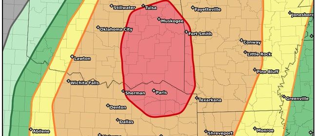
Although this storm packed a punch, there is still a threat for strong to severe thunderstorms tonight in the Dallas / Fort Worth Metroplex. We are in an “enhanced” risk of storms, a level 3 out of 5. Northeast Texas is at a level 4. We should expect a strong to severe squall line to hit this evening around the hours of 10PM – 12AM.
Stay tuned!


